| |
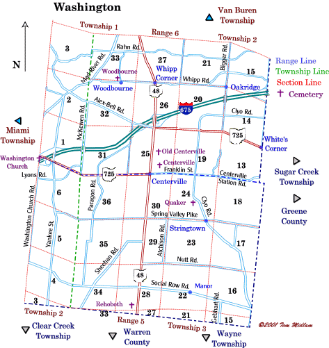
Cemeteries in Washington Township |
|
| Name |
Other Name |
Location |
Section |
Latitude / Longitude |
| Centerville |
|
North of Centerville Station Rd. and east of SR 48 |
25, SE1/4
T2, R6M.Rs.
|
|
| Centerville (old) |
|
East of SR 48 and south of Zengel Dr. in Centerville |
25, NE1/4
T2, R6M.Rs.
|
|
| Quaker |
Sears |
West side of Clyo Rd.and south of Quaker Way. (South ofCenterville Station Rd.)
|
24, SE1/4
T3, R5M.Rs.
|
|
| Rehobeth |
Hobart |
East of Pennfield Rd., north of Webbshaw Dr. and west of SR 48 |
28, SW1/4
T3, R5M.Rs.
|
|
| Washington Church |
|
Southeast corner of Southwind Dr. (old Washington Church Rd.) and SR 725 (Miamisburg Centerville Rd.) |
6, NW1/4
T2, R5M.Rs.
|
|
| Woodbourne |
|
Northwest corner of W. Whipp Rd and Padding Rd. |
32, NE1/4
T2, R6M.Rs.
|
|
|