| |
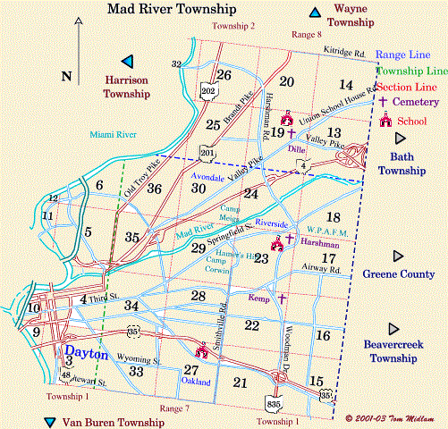
Cemeteries in Mad River Township |
|
| Name |
Other Name |
Location |
Section |
Latitude / Longitude |
| Cook |
Frank |
West of Old Troy Pike (SR 202 and north of Avondale Drive |
36, NE1/4
T2, R7M.Rs
|
39.798181°N 84.160461°W |
| Dille |
|
Northwest of Valley Pike and southwest of Union Schoolhouse Rd. |
19, NE1/4
T2, R8M.Rs
|
|
| Harshman |
Hashmanville |
Luther Ave. south of Bower St. in Riverside |
23, NE1/4
T2, R7M.Rs
|
|
| House of Jacob |
|
West side of Old Troy Pike (SR 202), south of NeedmoreRd. and Harshman Rd. |
26, SW1/4
T2, R8M.Rs
|
|
| Kemp |
|
South side of Denny Lane, west of Pandora Drive and east of Woodman Drive |
22, NE1/4
T2, R7M.Rs
|
|
| Jewish |
|
West side of Rubicon and north of Stewart St., moved Beth Abraham |
3, SE1/4
T1, R7M.Rs
|
moved |
| St. Henry Catholic |
|
West side of South Main St. across from fairgrounds (moved to Calvary before 1895) |
3, SW1/4
T1, R7M.Rs
|
moved |
| Woodland |
|
Main entrance at Woodland Ave. east of Brown St. |
33, SW1/4
T2, R7M.Rs
|
|
|