| |
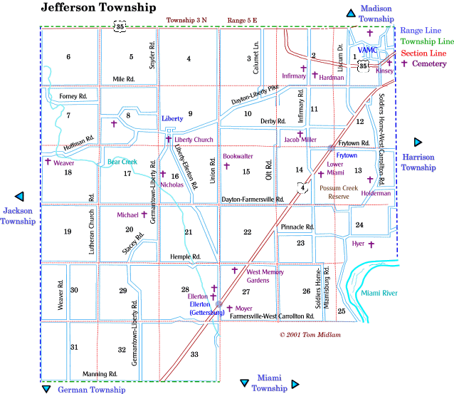
Cemeteries in Jefferson Township |
|
| Name |
Other Name |
Location |
Section
Trace, Range
|
Latitude / Longitude |
| Bookwalter |
Rohrer |
East of Union Rd. and north of Dayton-Farmersville Rd. |
15, NW1/4
T3N, R5E
|
|
| Burnett |
|
East side of Germantown-Liberty Rd. and south of Pemberton St. in Liberty |
9, SW1/4
T3N, R5E
|
39.718278°N
84.325139°W
|
|
|
|
West of Infirmary Rd., southof US 35, and northwest of Montgomery County Sheriff's Office parking lot behind building |
2, SW1/4
T3N, R5E
|
39.738417°N 84.282750°W |
|
Ellerton
|
Gettersburg |
West side of Union Rd. and north of SR 4 (Germantown Pike) |
28, SE1/4
T3N, R5E
|
|
| Forney |
|
South side of Forney Rd., west of Liberty and east of Lutheran Church Rd. |
8, SW1/4
T3N, R5E
|
|
| Hardman |
|
East side of Infirmary Rd. and north of Dayton-Liberty Pike , exact location unknown. |
2, SW1/4
T3N, R5E
|
unknown |
| Holderman |
Kaylor |
West of Soldier Home-West Carrolton Rd. and north of Caylor Rd. in Possum Creek Reserve |
13, SW1/4
T3N, R5E
|
|
| Hyer |
Stebbins |
South of Pinnacle Rd. and east of Soldier Home-West Carrolton Rd. |
24, SW1/4
T3N, R5E
|
|
| Kinsey |
|
South of West Third St. on VA Center grounds, exact location unknown |
1, SE1/4
T3N, R5E
|
unknown |
| Liberty Church |
|
South of Pemberton St. and east of Germantown-Liberty Rd. in Liberty |
9, SW1/4
T3N, R5E
|
|
| Lower Miami |
|
Southeast side of Dayton-Germantown Pike (SR4) and northeast of Infirmary Rd. near Possum Creek Reserve |
14, NE1/4
T3N, R5E
|
|
| Micheal |
|
South of Dayton-Farmersville Rd., exact location unknown |
20, NE1/4
T3N, R5E
|
unknown |
| Miller, Jacob |
|
South of Derby Rd. and west of Infirmary Rd. |
11, SE1/4
T3N, R5E
|
|
| Moyer |
Myer |
South of Ellerton, OH, north of Farmersville-West Carrolton Rd. and east of Union Rd. (Link to Myer Cemetery, 'Find a Grave') |
27, SW1/4
T3N, R5E
|
|
| Nicholas |
Hoffman |
East side of Germantown-Liberty Rd. and north of Dayton-Farmersville Rd. |
16, NW1/4
T3N, R5E
|
|
| Weaver |
|
South of Huffman Rd. and east of Diamond Mill Rd. |
18, NW1/4
T3N, R5E
|
|
| West Memory Garden |
|
Northwest of Germantown Pike (SR4) and south of Hemple Rd. |
27, NW1/4
T3N, R5E
|
|
|