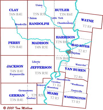
Montgomery County, OH > Township Cemetery Maps
Located in the First Meridian Survey and Between the Miamis Survey -- In the First Meridian (West of the Great Miami) Survey, Ranges are numbered starting at the First Meridian ( Indiana/Ohio state line) Montgomery County is in Ranges 4, 5 & 6 east. Townships are numbered northward from the Great Miami River. In the Between the Miamis Survey, Ranges are numbered northward from the Ohio River and Townships are eastward from the Great Miami River. The Greenville Treaty Line is the northern boundary for these surveys.
|
Township Maps
|
Communities
|
|
|
Little York,Vandalia
|
|
|
Arlington, Bachman, Brookville, Dodson
|
|
|
Germantown, Sunbury
|
|
|
Dayton
|
|
|
Farmersville, Johnville, New Lebanon
|
|
|
Ellerton, Gettersburg, Liberty
|
|
|
Dayton, Harshmanville
|
|
|
Post Town, Stillwater Juction, Trotwood
|
|
|
Alexandersville, Bridgeport, Miamisburg, West Carrollton
|
|
|
Air Hill, Brookville, Johnsville, New Lebanon, Pyrmont
|
|
|
Clayton, Englewood, Salem, Union
|
|
|
Dayton, Kettering, Moraine, Oakwood
|
|
|
Centerville, Woodbourne
|
|
|
Huber Heights
|
|
Sources:
Brookville Historical Society (BHS) 2003 website, Township maps by Tom Midlam
"1882 History of Montgmery County, Ohio" by W.H. Beers & Company
Montgmery County Chapter Ohio Genealogical Society (MCC-OGS) -
"Montgomery County, Ohio Cemetery Atlas" Second Edition" compiled by D.R. Bowman
Ohio Genealogical Society (OGS) - online cemetery search
Montgomery County, Ohio Auditor, GIS mapping and database
|
|