| |
Cemeteries in Randoph Township |
|
| Name |
Other Name |
Location |
Section |
Latitude / Longitude |
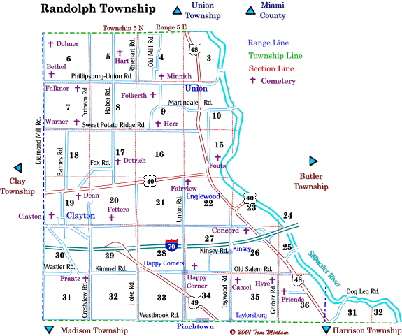
| Bethel |
|
North side of Phillipsburg-Union Rd. and east of Diamond Mill Rd. |
6, SW1/4
T5N, R5E
|
|
| Cassel |
|
East of Taywood Rd. and south of Old Salem Rd. (lost) |
35, NW1/4
T5N, R5E
|
|
| Clayton |
Salem |
West of Talmadge Rd. and north o Salem St. |
19, SW1/4
T5N, R5E
|
|
| Concord |
|
West of Covington Pike (US48) and south of Wenger Rd. in Englewood |
26, NW1/4
T5N, R5E
|
|
| Dean |
Jacob Smith |
South of US 40 National Rd., west of Talmadge Rd. and east of Swan Dr. |
19, NE1/4
T5N, R5E
|
|
| Detrich |
Miller |
East of Haber Rd. and north of Fox Rd. |
17, SE1/4
T5N, R5E
|
|
| Dohmer |
Shellabarger |
East of Diamond Mill Rd. and south of Montgmery County Line Rd. |
6, NW1/4
T5N, R5E
|
|
| Fairview |
Englewood |
Southest corner of US 40 National Rd. and Union Rd. in Englewood |
22, NW1/4
T5N, R5E
|
|
| Falknor |
|
South of Phillipsburg-Union Rd. and east of Diamond Mill Rd. |
7, NE1/4
T5N, R5E
|
|
| Fetters |
|
North of Wenger Rd. and east of Crestway Rd. |
20, SW1/4
T5N, R5E
|
|
| Folkerth |
|
West of Trimble Rd. and south of Phillipsburg-Union Rd. |
9, NW1/4
T5N, R5E
|
|
| Fouts |
Mengus |
East of Valleyview Dr. and north of US40 |
15, NE1/4
T5N, R5E
|
|
| Frantz |
|
Southwest corner of Kimmel Rd. and Crestway Rd. |
31, NE1/4
T5N, R5E
|
|
| Friends |
Quaker, Rocky Springs |
East of Garber Rd. and north of Westbrook Rd. |
36, NW1/4
T5N, R5E
|
|
| Happy Corner |
|
North side of Old Salem Rd. and east of Union Rd. in Englewood |
27, SW1/4
T5N, R5E
|
|
| Hart |
Rinehart |
West of Rinehart Rd. and north of Phillipsburg-Union Rd. |
5, SE1/4
T5N, R5E
|
|
| Herr |
Old Warner |
North side of Sweet Potato Ridge Rd. and west of SR 49 in Union |
9, SW1/4
T5N, R5E
|
|
| Hyre |
|
South side of Old Salem Rd. and west of Garber Rd. (gone) |
35, NE1/4
T5N, R5E
|
|
| Minnich |
|
North side of Phillipsburg-Union Rd. and west of SR 48 at Union |
4, SE1/4
T5N, R5E
|
|
| Warner |
|
North side of Sweet Potato Rd. and east of Diamond Mill Rd. |
7, SE1/4
T5N, R5E
|
|
|