| |
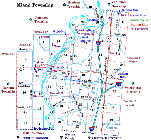
Cemeteries in Miami Township |
|
| Name |
Other Name |
Location |
Section |
Latitude / Longitude |
| Butt |
Munger |
West of Munger Rd. bend at Forestdean Ct. junction, extinct (Remains moved to David Cemetery) |
8, SW1/4
T1N, R6E
|
moved |
| Evergreen |
|
Northeast side of N. Miami Ave, (the contiuation of Farmersville-West Carrollton Rd.) in West Carollton |
21, NW1/4
T1N, R6E
|
|
| Gebhart Church |
|
Northwest corner of Maue Rd. and S. Gebhart Church Rd. |
19, SW1/4
T1N, R6E
|
|
| Highland Memorial |
|
North side of SR 725 west of Miamidburg |
3, SW1/4
T2N, R5E
|
|
| Hill Grove |
|
East end of Park St. and east of Cole St. in Miamisburg |
25, S1/2
T1N, R6E
|
|
| Lutheran Church |
Miamisburg #1 |
moved |
31, N1/2
T1N, R6E
|
moved |
| Miamisburg #2 |
|
moved |
25, SW1/4
T1N, R6E
|
moved |
| Miamisburg #3 |
|
moved |
25, NW1/4
T1N, R6E
|
moved |
| Miamisburg Catholic |
|
Southeast corner of Kercher St. and Ninth St. in Miamisburg |
25, NW1/4
T1N, R6E
|
|
| Mound |
Benner, Rungrey, Ungerer |
North of Benner Rd. and east of Mound Rd. |
30, SE1/4
T1N, R6E
|
|
| Moyer |
|
East of Soldiers Home -Miamisburg Rd. |
35, SW1/4
T3N, R5E
|
|
| Root |
|
South of Linden Ave. and east of Union Rd., exact location unknown |
10, NW1/4
T2N, R5E
|
|
| Stettler |
|
East side of Union Rd. north Farmington Rd. |
15, NW1/4
T2N, R5E
|
|
| Troxel |
|
South side Farmersville-West Carrollton Rd. and east of Union Rd. |
34, NW1/4
T2N, R5E
|
|
| Zion Church |
|
Southeast corner of W. Stroop Rd. and S. Dixie Dr. west of Lamme Rd. |
10, NW1/4
T1N, R6E
|
|
|