| |
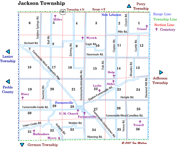
Cemeteries in Jackson Township |
|
| Name |
Other Name |
Location |
Section |
Latitude / Longitude |
| Farmersville |
|
South of Dallas & Elm Street in Farmersville |
28, SE14
T4N, R4E
|
|
| Farmersville U.B. Church |
|
South side of Center St. behind church in Farmersville |
28, NE1/4
T4N, R4E
|
|
| Hisey |
Stiver, Stover |
North of Farmersville-Gratis Rd. & east of Preble County Line Rd. |
19, SW1/4
T4N, R4E
|
|
| Holp |
|
West side of Clayton Rd. just north of Chicken Brisle Rd. |
14, SE1/4
T4N, R4E
|
|
| Leslie |
|
West of Fuls Rd. and south of Chicken Brisle Rd. |
22, SE1/4
T4N, R4E
|
|
| Miller |
Priser |
East side of Bull Rd. and south of US 35 |
5. NE1/4
T4N, R4E
|
|
| Mullendore |
|
980' East of Preble County Line Rd. and .4 mi. north of Baden Rd. |
31, SW1/4
T4N, R4E
|
|
| Myers |
|
West of Anthony Rd. at Manning Rd. north of Twin Creek |
32, SW1/4
T4N, R4E
|
|
| Old Presbyterian |
Troxell |
South of Farmersville-West Carrollton Rd. and west of Diamond Mill Rd. |
36, NE1/4
T4N, R4E
|
|
| Shideler |
|
West of Venus Rd. approximately 900' and north of Manning Rd. approximately .43 mile. (location currently not marked on township map) |
35, SE1/4
T4N, R4E
|
|
| Slifer |
|
West side of Clayton Rd. just south of Chicken Brisle Rd. |
23, NW1/4
T4N, R4E
|
|
| Trissel |
|
West side of Diamond Mill Rd. and south of US 35 |
1, SE1/4
T4N, R4E
|
|
| Wyrick |
|
West of Farmersville-Johnsville Rd. and north of Dechant Rd. |
9, NE1/4
T4N, R4E
|
|
|