| Montgomery County, OH > Butler Township |
|
| |
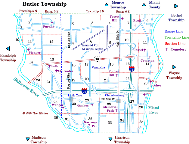
Cemeteries in Butler Township |
|
| Name |
Other Name |
Cemetery Location |
Section |
Latitude / Longitude |
| Booher |
|
West of Cassel Rd., north of Poplar Creek Rd. and south of Taylorsville Dam. |
23, NE1/4
T3N, R6E
|
|
| Cassel |
Holderman, Sunderland |
West side of N. Cassel Rd. and north of Old Falls Dr. |
11, SW1/4
T3N, R6E
|
|
| Compton |
Morgan |
US 40 and Taylorsview Dr. (graves moved to Poplar Hill Cemetary) |
14, NW1/4
T3N, R6E
|
|
| Dayton Memorial Park |
Memorial Park |
West side of North Dixie Dr. and south of Little York Rd. |
33, NE1/4
T3N, R6E
|
|
| Forest Hills |
|
East side of North Dixie Dr. just south of Lightner Rd. |
3, MW1/4
T3N, R6E
|
|
| Friends |
Quaker, Randolph |
South side of Little York Rd. east of Peters Pike |
29, SE1/4
T3N, R6E
|
|
| Furnas |
Surgar Grove |
West side of Furnas Rd. north of Old Springfield Rd. and east of Fredrick Pike |
1, SW1/4
T5N, R5E
|
|
| German |
Stillwater Lutheran Church |
North of eastbound lane at 8900 Frederick Pike just south of Meeker Rd. and north of Kreshner Rd. |
13, SE1/4
T5N, R5E
|
|
| Hosier |
|
West side of I-75 and north of Little York Rd. (graves moved to Polk Grove Cemetery) |
27, NW1/4
T3N, R6E
|
graves moved |
| Kessler |
|
North of Martindale Rd. and west of Kley Rd. |
11, SW1/4
T5N, R5E
|
TBD |
| Narrows Pet |
|
Northeast side of Frederick Pike and southeast of Petes Pike |
32, SW1/4
T3N, R6E
|
|
| Pioneer |
Friends, Old Randolph |
South of Martindale Rd. east of Stillwater River, (lost) |
11, SW1/4
T5N, R5E
|
lost |
| Polk Grove |
Maple Grove, Polk Church |
Southeast corner of US 40 and Frederick Pike |
13, W1/2
T5N, R5E
|
|
| Poplar Hill |
Vandalia |
West side of North Dixie Dr. and north of Stonequarry Rd. in Vandalia |
21, NE1/4
T3E, R6E
|
|
| Reed |
|
North side of Old Springfield Rd., east of Engle Rd. and east of I-75 |
3, SE1/4
T3N, R6E
|
|
| U.B. Church |
Old Vandalia |
East side of South Dixie Drive and south of National Rd. (moved to Poplar Hill) |
15, NW1/4
T3N, R6E
|
moved |
| Unnamed |
|
North of Poplar Creek Rd., south of I-70 and east of Brown School Rd. |
26, NW1/4
T3N, R6E
|
|
| Wenger |
|
West of Frederick Pike and north of Meeker Rd. |
30, SW1/4
T3N, R6E
|
|
|