| |
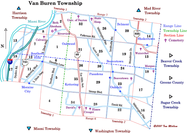
Cemeteries in Van Buren Township |
|
| Name |
Other Name |
Location |
Section |
Latitude / Longitude |
| Beavertown |
Ewry, Stutsman |
Cemetery Rd. east of Vallywood and south of Dorothy Lane |
23, NE1/4
T2E, R6N
|
|
| Beth Abraham |
Jewish |
North side of Schantz Ave. and west of Far Hills (SR48) in Oakwood |
2, SW1/4
T1E, R7N
|
|
| Calvary |
Catholic |
West side of South Patterson Blvd. and south of Carilton Park |
7, NE1/4
T1E, R7N
|
|
| Creager |
|
South of David Rd. and east of SR48 (moved to David Cemetery) |
28, SW1/4
T2E, R6N
|
moved |
| David's Church |
|
South of David Rd., between SR48 and Mad River Rd. |
34, SW1/4
T2E, R6N
|
|
| Himes |
|
South of David Rd. and east of SR48 (moved to David Cemetery |
28, SW1/4
T2E, R6N
|
moved |
| Morgan |
|
West of County Line Rd. and north of Dorothy Lane |
18, NE1/4
T2E, R6N
|
lost |
| Riverview |
|
North side of Schantz Ave. and east of Beth Abraham Cemetery in Oakwood |
2, SW1/4
T1E, R7N
|
|
| State Hospital |
|
North of Irving Ave. and west of Firwood Dr. in Dayton |
32, NE1/4
T2E, R7N
|
|
| University of Dayton |
|
South of Stewart St., adjoining Woodland Cemetery |
32, NW1/4
T2E, R7N
|
|
| Unnamed |
|
West of Calvary Cemetery near half-section line, Potters field for Calvary Cemetery, exact location unknown, may be near I-75 or Sandridge Dr. |
7, NE1/4
T1E, R7N
|
unknown |
| Watervliet |
Shaker |
South of Patterson Rd. and west of Spaulding Rd. (lost) |
13, N1/2
T1E, R7N
|
lost |
|