| |
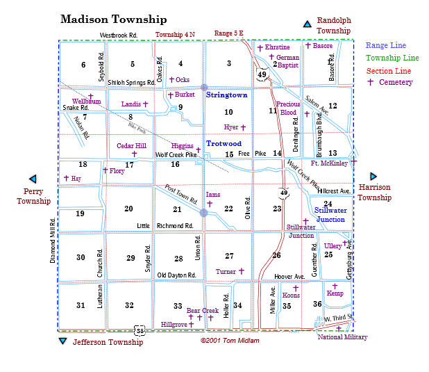
Cemeteries in Madison Township |
|
| Name |
Other Name |
Location |
Section |
Latitude / Longitude |
| Basore |
Bashore, Baesore |
South of Westbrook Rd. and east of Denlinger Rd. |
1, NW1/4
T4N, R5E
|
|
| Bear Creek East |
|
East Side of Union Rd. and north of US 35, west of Dayton |
34, SW1/4
T4N, R5E
|
|
| Bear Creek West |
|
West side of Union Rd. and north of US 35, west of Dayton |
33, SE1/4
T4N, R5E
|
|
| Bear Creek Old |
Bowman, Vaniman, Woodin |
West side of Union Rd. and north of US 35, west of Dayton |
33, SE1/4
T4N, R5E
|
|
| Burket |
Myers |
South of Shiloh Springs Rd., east of Oaks Rd. and west of New Fields Blvd. |
9, NW1/4
T4N, R5E
|
|
| Cedar Hill |
Kuns, Plainview |
North side of Wolf Creek Pike, west of Snyder Rd. and est of Diamond Mill Rd. |
17, NE1/4
T4N, R5E
|
|
| Ehrstine |
|
East of Salem Bend Rd. and south of Westbrook Rd. at Taylorsburg |
2, NW1/4
T4N, R5E
|
|
| Flory |
|
South of Wolf Creek Pike and east of Lutheran Church Rd. |
18, SE1/4
T4N, R5E
|
|
| Fort McKinley |
|
Southeast corner of Gettyburg Ave. and Free Pike west of Salem Ave. |
13, SE1/4
T4N, R5E
|
|
| Hay |
Foutz, Pfoutz |
East of Diamond Mill Road and north of Post Town Road. |
18, SW1/4
T4N, R5E
|
39.791832°N 84.365218°W |
| Higgins |
|
West of Union Rd. and north of Wol Creek Pike, exact location unknown |
16, NE1/4
T4N, R5E
|
unknown |
| Hillgrove |
|
North side of US 35 and west of Union Rd. |
33, SE1/4
T4N, R5E
|
|
| Iams |
Pauley, Powell |
East side of Union Rd. and north of Post Town Rd. |
22 NW1/4
T4N, R5E
|
|
| Issac Hyer |
|
West of Olive Rd. and south of Fairgrove Way |
10 SE1/4
T4N, R5E
|
exact location unknown |
| Kemp |
|
Lost |
36, NE1/4
T4N, R5E
|
unknown |
| Koons |
|
Lost |
35, NE1/4
T4N, R5E
|
unknown |
| Landis |
|
Lost |
8, NE1/4
T4N, R5E
|
unknown |
| Oaks Farm |
|
East of Oaks Rd. and north of Shiloh Springs Rd., a small abondoned family cemetery, approx. 50' x 50' |
4, SW1/4
T4N, R5E
|
|
| Old German Baptist |
Dunker Church, Lower Stillwater |
North side of Salem Bend Rd. and southeast of Nantucker Rd. |
2, W1/2
T4N, R5E
|
|
| Precious Blood |
|
Southwest of Salem Rd. and east of Denlinger Rd. |
2. W1/2
T4N, R5E
|
|
| Stillwater Junction |
|
Lost |
24, SW1/4
T4N, R5E
|
lost |
| Turner |
Bright, Metzger, Shively |
West of Olive Rd. and north of Hoover Ave. |
27, SE1/4
T4N, R5E
|
|
| Ullery |
Stillwater Junction |
South of Little Richmond Rd. and east of Western Ave. |
25, NE1/4
T4N, R5E
|
|
| Wellbaum |
Murray |
South of Shiloh Springs Rd. and east of Diamond Mill Rd. |
7, NE1/4
T4N, R5E
|
|
|